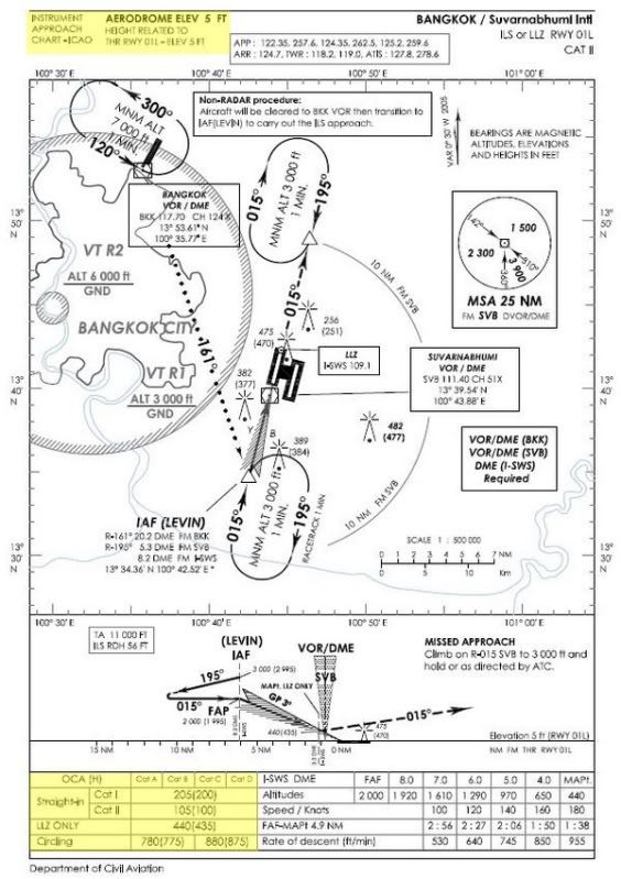
Obstacle Clearance เป็นระยะสูงที่วัดจากสิ่งกีดขวาง (Obstacle) ขึ้นไปเป็นค่าความสูงค่าหนึ่ง ซึ่งในทางการบินแล้วสิ่งกีดขวางถือเป็นสิ่งที่ไม่พึงปรารถนาอย่างหนึ่ง เพราะถ้าเราไม่เฉี่ยวชนก็อาจจะเกิดอุบัติเหตุขึ้นได้ ดังนั้นในการปฏิบัติการบินของเครื่องบินนั้นจะต้องมีการกำหนดระยะสูงปลอดภัย ขึ้นมาค่าหนึ่งนั่นคือ OCA/H : Obstacle Clearance Altitude/Height นั่นเองซึ่งเป็นค่าที่ปรากฏอยู่ใน Approach Chart ทั่วๆไปนั่นเอง

Instrument Approach Chart – VTBS RWY 01L
ก่อน หน้าที่จะทำความรู้จักว่า OCA/H, MDA/H และ DA/H มันมาได้อย่างไร ต้องมีพื้นฐานความรู้กันเสียก่อนเกี่ยวกับคำว่า Height และ Altitude เนื่องจากการวัดความสูงของเครื่องบินโดยเครื่องวัด Altimeter จะเป็นแบบ Barometric Pressure Altitude หมายความว่า “วัดความสูงจากความกดอากาศแล้วเทียบออกมาเป็นความสูง” สำหรับ Height นั้นเป็นความสูงที่วัดจากระดับอ้างอิง (ในที่นี้หมายถึง Runway หรือ Aerodrome Elevation) ซึ่งการรายงานความกดอากาศเพื่อ Altimeter Setting นั้นจะอยู่ในรูปของ QFE เมื่อนักบินปรับเป็นค่า QFE แล้วนั้น Altimeter จะชี้ที่ 0 ft พอดีในขณะที่อยู่บนทางวิ่ง ส่วน Altitude นั้นเป็นความสูงที่วัดจากระดับน้ำทะเลปานกลาง (MSL : Mean Sea Level) จะรายงานในรูป QNH เมื่อนักบินปรับค่าแล้ว Altimeter จะชี้ที่ Runway/Aerodrome Elevation ขณะที่อยู่บนทางวิ่ง

ประเภทของ Approach นั้นจะแยกออกเป็น 2 ประเภทคือ
1. Straight-in Approach – ขั้นตอนการปฏิบัตินั้นจะแบ่งได้ออกเป็น 2 ประเภท คือ Precision Approach Procedures การบินเข้าหานั้นจะเป็นแนวเดียวกันกับเส้นกึ่งกลางทางวิ่ง (Runway Center Line) และ Non-Precision Approach Procedures การบินเข้าหานั้นจะเป็นแนวเดียวกันกับเส้นกึ่งกลางทางวิ่ง โดยที่มุมที่วัดออกจากเส้นกึ่งกลางทางวิ่งนั้นจะต้องไม่เกิน 30 องศา
2. Circling Approach – เนื่องจากข้อจำกัดในการบินเข้า ทำให้ต้องมีขั้นตอนในการบินลงโดยการทำท่าทางต่างๆ เช่น 45/180 Procedure Turn, 80/260 Procedure Turn, Base Turns, Racetrack Procedures เป็นต้น
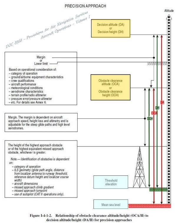
Precision Approach Procedure เป็นที่การบินเข้าหาโดยใช้เครื่องช่วยร่อน (Guidance System จะต้องให้ทั้งสองแนวคือ Lateral และ Vertical) เช่น ILS, MLS เป็นต้น วิธีการกำหนด OCA/H นั้นจะคิดจากความสูงของสิ่งกีดขวางที่สูงที่สุดในบริเวณการบินเข้าหานั้นๆ แล้วบวกด้วยค่าความสูงปลอดภัย (Safety Margin) เพิ่มเข้าไป (ค่านี้ขึ้นกับปัจจัยหลายๆอย่างเช่น Approach Speed, Guide Path เป็นต้น) จะเห็นได้ว่าจะมีค่าความสูงอยู่สองค่า คือ OCH จะวัดจากความสูงของทางวิ่ง (Runway Threshold Elevation) ส่วน OCA จะวัดจากระดับน้ำทะเลปานกลาง (MSL : Mean Sea Level) ซึ่งค่า OCA/H นี้เป็นความสูงที่ต่ำที่สุดที่กำหนดโดยหน่วยงานที่รับผิดชอบ เครื่องบินไม่สามารถลดระดับได้ต่ำกว่าค่านี้ถ้าหากไม่เห็นทางวิ่ง แต่เมื่อทางนักบินหรือสายการบินเอาไปใช้ในการปฏิบัติการจะบวกค่าความสูง Operational Factors เข้าไปเพื่อเป็นความสูงในการที่จะตัดสินใจว่าจะลงหรือไปใหม่ (Go Around หรือ Missed Approach) เรียกว่า “ความสูงตัดสินใจ (DA/H : Decision Altitude/Height)” (ขึ้น กับปัจจัยต่างๆ เช่น Category of Operation, Aircraft Performance, Terrain Profiles, Aerodrome Characteristics เป็นต้น) ค่า DA/H เป็นค่าที่มีความสำคัญ เพราะถ้าหากลดระดับลงมาถึงจุดนี้แล้วไม่เห็นทางวิ่ง นักบินจะต้องบินไปจนถึง MAPt : Missed Approach Point ทำการไปใหม่ (Go Around หรือ Missed Approach) เท่านั้น

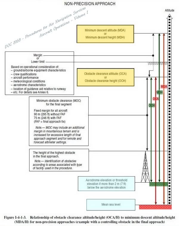
Non-precision Approach Procedure เป็นการบินโดยใช้เครื่องช่วยเดินอากาศ เช่น VOR, NDB รวมไปถึง Localizer (ให้ Guidance ในแนว Lateral เท่านั้น) OCA/H นั้นจะคิดจากความสูงของสิ่งกีดขวางที่สูงที่สุดในบริเวณการบินเข้าหานั้นๆ แล้วบวกด้วยค่า MOC : Minimum Obstacle Clearance ในส่วนของ Final Segment ถ้าหากมีการกำหนดจุด FAF : Final Approach Fixed จะใช้ 75 เมตร แต่ถ้าหากไม่มี FAF จะใช้ 90 เมตร ค่า OCA/H ใน Non-precision Approach Procedure จะวัดจากความสูงของสนามบินวัดจากระดับน้ำทะเล (Aerodrome Elevation) แต่ถ้าหากความสูงทางวิ่ง (Runway Threshold Elevation) ต่ำกว่าความสูงสนามบินมากกว่า 2 เมตร จะใช้ค่าความสูงของทางวิ่งทันที เมื่อนักบินหรือสายการบินนำไปปฏิบัติการบินไปบวกด้วย Operational Factors จะได้ออกมาเป็นค่าของ “ความสูงต่ำสุดในการลดระดับ (MDA/H : Minimum Descent Altitude/Height)” นั่นเอง เมื่อลดระดับลงมาถึงความสูงนี้แล้วยังไม่เห็นทางวิ่งจะสามารถเลือกบินรักษา ระดับไปจนกระทั่งถึงจุด MAPt : Missed Approach Point โดยก่อนถึง MAPt มองเห็นทางวิ่งจะสามารถร่อนลงได้เลย แต่ถ้าบินถึง MAPt โดยที่ไม่เห็นทางวิ่งแล้วนั้นนักบินจะต้องทำการไปใหม่ (Go Around หรือ Missed Approach) เท่านั้น

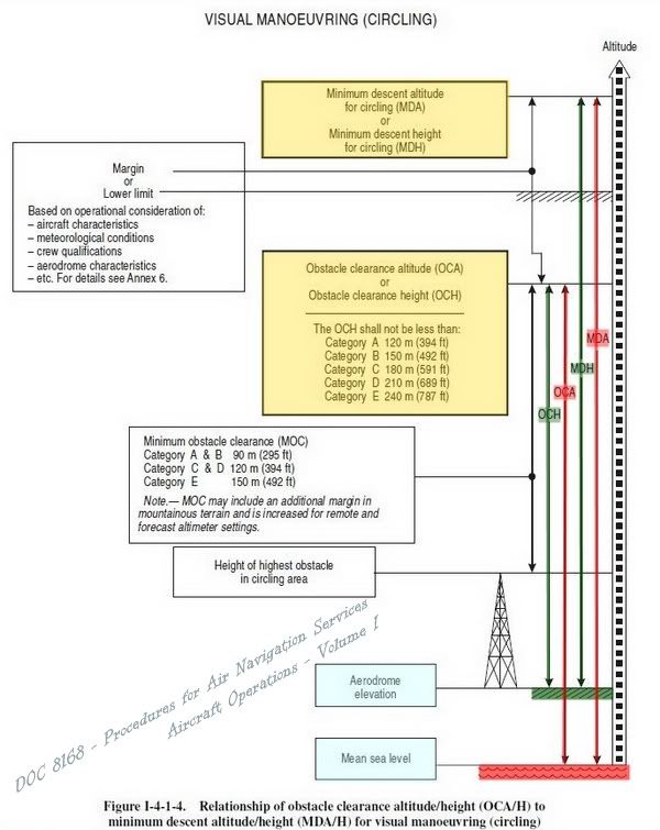
Visual (Circling) Approach Procedure เป็นวิธีการบินเข้าชนิดหนึ่ง ซึ่งการบินเข้าในลักษณะนี้จะต้องทำมุมบินเข้าหามากกว่า 30 องศาขึ้นไปเมื่อวัดจากเส้นกึ่งกลางทางวิ่งด้านที่จะลง OCA/H นั้นจะคิดจากความสูงของสิ่งกีดขวางที่สูงที่สุดในบริเวณการบินเข้าหานั้นๆ แล้วบวกด้วยค่า MOC : Minimum Obstacle Clearance ในส่วนของ Final Segment ซึ่งจะแตกต่างกันออกไปตาม Category ของเครื่องบิน เมื่อนักบินหรือสายการบินนำไปปฏิบัติการบินไปบวกด้วย Operational Factors จะได้ออกมาเป็นค่าของ “ความสูงต่ำสุดในการลดระดับ (MDA/H : Minimum Descent Altitude/Height)” เมื่อลดระดับลงมาถึงความสูงนี้แล้วยังไม่เห็นทางวิ่งจะสามารถเลือกบินรักษา ระดับไปจนกระทั่งถึงจุด MAPt : Missed Approach Point โดยก่อนถึง MAPt มองเห็นทางวิ่งจะสามารถร่อนลงได้เลย แต่ถ้าบินถึง MAPt โดยที่ไม่เห็นทางวิ่งแล้วนั้นนักบินจะต้องทำการไปใหม่ (Go Around หรือ Missed Approach) เท่านั้น

DEFINITIONS
Aerodrome elevation. The elevation of the highest point of the landing area.
Altitude. The vertical distance of a level, a point or an object considered as a point, measured from mean sea level (MSL).
Decision altitude (DA) or decision height (DH). A specified altitude or height in the precision approach or approach with vertical guidance at which a missed approach must be initiated if the required visual reference to continue the approach has not been established.
Note 1.— Decision altitude (DA) is referenced to mean sea level and decision height (DH) is referenced to the threshold elevation.
Note 2.— The required visual reference means that section of the visual aids or of the approach area which should have been in view for sufficient time for the pilot to have made an assessment of the aircraft position and rate of change of position, in relation to the desired flight path. In Category III operations with a decision height the required visual reference is that specified for the particular procedure and operation.
Note 3.— For convenience where both expressions are used they may be written in the form “decision altitude/height” and abbreviated “DA/H”.
Elevation. The vertical distance of a point or a level, on or affixed to the surface of the earth, measured from mean sea level.
Height. The vertical distance of a level, a point or an object considered as a point, measured from a specified datum.
Minimum descent altitude (MDA) or minimum descent height (MDH). A specified altitude or height in a non-precision approach or circling approach below which descent must not be made without the required visual reference.
Note 1.— Minimum descent altitude (MDA) is referenced to mean sea level and minimum descent height (MDH) is referenced to the aerodrome elevation or to the threshold elevation if that is more than 2 m (7 ft) below the aerodrome elevation. A minimum descent height for a circling approach is referenced to the aerodrome elevation.
Note 2.— The required visual reference means that section of the visual aids or of the approach area which should have been in view for sufficient time for the pilot to have made an assessment of the aircraft position and rate of change of position, in relation to the desired flight path. In the case of a circling approach the required visual reference is the runway environment.
Note 3.— For convenience when both expressions are used they may be written in the form “minimum descent altitude/height” and abbreviated “MDA/H”.
Missed approach point (MAPt). That point in an instrument approach procedure at or before which the prescribed missed approach procedure must be initiated in order to ensure that the minimum obstacle clearance is not infringed.
Obstacle clearance altitude (OCA) or obstacle clearance height (OCH). The lowest altitude or the lowest height above the elevation of the relevant runway threshold or the aerodrome elevation as applicable, used in establishing compliance with appropriate obstacle clearance criteria.
Note 1.— Obstacle clearance altitude is referenced to mean sea level and obstacle clearance height is referenced to the threshold elevation or in the case of non-precision approaches to the aerodrome elevation or the threshold elevation if that is more than 2 m (7 ft) below the aerodrome elevation. An obstacle clearance height for a circling approach is referenced to the aerodrome elevation.
Note 2.— For convenience when both expressions are used they may be written in the form “obstacle clearance altitude/height” and abbreviated “OCA/H”.
Threshold (THR). The beginning of that portion of the runway usable for landing.
อ้างอิงจาก DOC 8168 - Procedures for Air Navigation Services - Aircraft Operations - Volume I